![](/images/other/stat-length.png)
![Trail Mountain bike Le Bourget-du-Lac - Descente du Chat - Photo](https://media.geolcdn.com/t/1900/400/ext.pjpeg?maxdim=2&url=https%3A%2F%2Fstatic1.geolcdn.com%2Fsiteimages%2Fupload%2Ffiles%2F1524743154velo.jpg)
Descente du Chat
misterzou
User
![Length](/images/other/stat-length.png)
Length
10.4 km
![Max alt](https://static1.geolcdn.com/siteimages/upload/files/1508320355ic_sort_altitude_max_24dp.png)
Max alt
1491 m
![Uphill gradient](https://static1.geolcdn.com/siteimages/upload/files/1508320355ic_sort_den_pos_24dp.png)
Uphill gradient
36 m
![Km-Effort](/images/other/stat-length.png)
Km-Effort
15 km
![Min alt](https://static1.geolcdn.com/siteimages/upload/files/1508320355ic_sort_altitude_min_24dp.png)
Min alt
233 m
![Downhill gradient](https://static1.geolcdn.com/siteimages/upload/files/1508320355ic_sort_den_neg_24dp.png)
Downhill gradient
1286 m
![Boucle](https://static1.geolcdn.com/siteimages/upload/files/16400158638029165_repeat_loop_refresh_sync_direction_icon.png)
Boucle
No
Creation date :
2017-09-01 00:00:00.0
Updated on :
2017-09-01 00:00:00.0
![Mountain bike](https://static1.geolcdn.com/sitytour/trail-icons/202.png)
45m
Difficulty : Medium
![Scan this QR Code to open this trail in the SityTrail application](https://capi.geolives.com/qq0zvz2zws4bq2lad0pu/sitytour/trails/115730/qr.png?size=200)
FREE GPS app for hiking
About
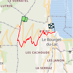
Trail Mountain bike of 10.4 km to be discovered at Auvergne-Rhône-Alpes, Savoy, Le Bourget-du-Lac. This trail is proposed by misterzou.
Description
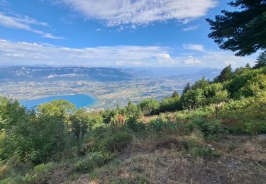
Mont du Chat (Ladonchamps)
VTOPO Savoie Tome 1
Topo N°9 page 44
Premiers virages difficiles après ca va mieux en restant bien soutenu (Niveau 3 VTOPO)
Positioning
Country:
France
Region :
Auvergne-Rhône-Alpes
Department/Province :
Savoy
Municipality :
Le Bourget-du-Lac
Location:
Unknown
Start:(Dec)
Start:(UTM)
719812 ; 5060249 (31T) N.
Comments
Trails nearby
![Trail Walking Le Bourget-du-Lac - La Dent du Chat 1390m, le Molard Noir 1452m - Photo](https://media.geolcdn.com/t/375/260/ext.jpg?maxdim=2&url=https%3A%2F%2Fservices.sitytrail.com%2FGeolivesWS%2FDownloadMedia.ashx%3FTrailID%3D102504%26Media%3D3313_1.jpg)
![Walking Walking](https://static1.geolcdn.com/sitytour/trail-icons/101.png)
La Dent du Chat 1390m, le Molard Noir 1452m
Walking
Difficult
(4)
Le Bourget-du-Lac,
Auvergne-Rhône-Alpes,
Savoy,
France
![](/images/other/stat-length.png)
6.6 km | 13.7 km-effort
3h 30min
![](https://static1.geolcdn.com/siteimages/upload/files/16400158638029165_repeat_loop_refresh_sync_direction_icon.png)
Yes
![Trail Mountain bike Le Bourget-du-Lac - Chartreuse - Col du Crucifix - Photo](https://media.geolcdn.com/t/375/260/ext.jpg?maxdim=2&url=https%3A%2F%2Fservices.sitytrail.com%2FGeolivesWS%2FDownloadMedia.ashx%3FTrailID%3D102126%26Media%3D2516_1.jpg)
![Mountain bike Mountain bike](https://static1.geolcdn.com/sitytour/trail-icons/202.png)
Chartreuse - Col du Crucifix
Mountain bike
Difficult
(2)
Le Bourget-du-Lac,
Auvergne-Rhône-Alpes,
Savoy,
France
![](/images/other/stat-length.png)
27 km | 40 km-effort
4h 0min
![](https://static1.geolcdn.com/siteimages/upload/files/16400158638029165_repeat_loop_refresh_sync_direction_icon.png)
Yes
![Trail Walking Saint-Jean-de-Chevelu - st jean le chevelu - Photo](https://media.geolcdn.com/t/375/260/f752bdfc-b9bc-4dfb-b673-6eb9a7dfceae.jpg&format=jpg&maxdim=2)
![Walking Walking](https://static1.geolcdn.com/sitytour/trail-icons/101.png)
st jean le chevelu
Walking
Difficult
Saint-Jean-de-Chevelu,
Auvergne-Rhône-Alpes,
Savoy,
France
![](/images/other/stat-length.png)
15.4 km | 23 km-effort
6h 51min
![](https://static1.geolcdn.com/siteimages/upload/files/16400158638029165_repeat_loop_refresh_sync_direction_icon.png)
Yes
![Trail Walking Saint-Jean-de-Chevelu - La dent du chat - Photo](https://media.geolcdn.com/t/375/260/ext.jpg?maxdim=2&url=https%3A%2F%2Fstatic1.geolcdn.com%2Fsiteimages%2Fupload%2Ffiles%2F1553511878bg_sport_marche.png)
![Walking Walking](https://static1.geolcdn.com/sitytour/trail-icons/101.png)
La dent du chat
Walking
Difficult
(1)
Saint-Jean-de-Chevelu,
Auvergne-Rhône-Alpes,
Savoy,
France
![](/images/other/stat-length.png)
3.1 km | 9.8 km-effort
1h 30min
![](https://static1.geolcdn.com/siteimages/upload/files/16400158638029165_repeat_loop_refresh_sync_direction_icon.png)
No
![Trail Via ferrata La Chapelle-du-Mont-du-Chat - 2011-04-03 via ferrata Col du chat - Photo](https://media.geolcdn.com/t/375/260/ext.jpg?maxdim=2&url=https%3A%2F%2Fstatic1.geolcdn.com%2Fsiteimages%2Fupload%2Ffiles%2F1545311037marcheuse_200dpi.jpg)
![Via ferrata Via ferrata](https://static1.geolcdn.com/sitytour/trail-icons/902.png)
2011-04-03 via ferrata Col du chat
Via ferrata
Easy
(1)
La Chapelle-du-Mont-du-Chat,
Auvergne-Rhône-Alpes,
Savoy,
France
![](/images/other/stat-length.png)
3.6 km | 6.8 km-effort
Unknown
![](https://static1.geolcdn.com/siteimages/upload/files/16400158638029165_repeat_loop_refresh_sync_direction_icon.png)
No
![Trail Walking Le Bourget-du-Lac - Dent du Chat, Mollard Noir, Refuge du Relais du Chat au départ du Sentier Botanique - Photo](https://media.geolcdn.com/t/375/260/89fa4c90-58f1-4891-bad5-9bd4924cd4f6.jpg&format=jpg&maxdim=2)
![Walking Walking](https://static1.geolcdn.com/sitytour/trail-icons/101.png)
Dent du Chat, Mollard Noir, Refuge du Relais du Chat au départ du Sentier B...
Walking
Medium
Le Bourget-du-Lac,
Auvergne-Rhône-Alpes,
Savoy,
France
![](/images/other/stat-length.png)
12.8 km | 25 km-effort
4h 0min
![](https://static1.geolcdn.com/siteimages/upload/files/16400158638029165_repeat_loop_refresh_sync_direction_icon.png)
Yes
![Trail Walking La Chapelle-du-Mont-du-Chat - 270523 Tour et Dent du Chat - Photo](https://media.geolcdn.com/t/375/260/0a1b231b-4827-4287-a183-6427b560c2c1.jpg&format=jpg&maxdim=2)
![Walking Walking](https://static1.geolcdn.com/sitytour/trail-icons/101.png)
270523 Tour et Dent du Chat
Walking
Easy
La Chapelle-du-Mont-du-Chat,
Auvergne-Rhône-Alpes,
Savoy,
France
![](/images/other/stat-length.png)
10 km | 21 km-effort
4h 15min
![](https://static1.geolcdn.com/siteimages/upload/files/16400158638029165_repeat_loop_refresh_sync_direction_icon.png)
Yes
![Trail Walking Le Bourget-du-Lac - mixte Pierre Nioule/croix du signal - Photo](https://media.geolcdn.com/t/375/260/c4b92019-89a6-4bfe-818d-fe93f3447b41.jpg&format=jpg&maxdim=2)
![Walking Walking](https://static1.geolcdn.com/sitytour/trail-icons/101.png)
mixte Pierre Nioule/croix du signal
Walking
Easy
Le Bourget-du-Lac,
Auvergne-Rhône-Alpes,
Savoy,
France
![](/images/other/stat-length.png)
11 km | 21 km-effort
3h 0min
![](https://static1.geolcdn.com/siteimages/upload/files/16400158638029165_repeat_loop_refresh_sync_direction_icon.png)
Yes
![Trail Walking Le Bourget-du-Lac - Le Molard du mont du Chat - Photo](https://media.geolcdn.com/t/375/260/ec8abf10-1e1d-496d-bf4f-ea01891581c4.jpg&format=jpg&maxdim=2)
![Walking Walking](https://static1.geolcdn.com/sitytour/trail-icons/101.png)
Le Molard du mont du Chat
Walking
Very easy
(1)
Le Bourget-du-Lac,
Auvergne-Rhône-Alpes,
Savoy,
France
![](/images/other/stat-length.png)
3.1 km | 4.5 km-effort
1h 32min
![](https://static1.geolcdn.com/siteimages/upload/files/16400158638029165_repeat_loop_refresh_sync_direction_icon.png)
Yes